Measuring distance on the map
This topic describes how to measure distances on the map of both the ESPA analysis center screen.
You can also click here for a short video showing how to use map drawing mode, including the measure distance mode.
-
Open your case on the ESPA analysis center screen as described in Getting started with investigating case data visually.
-
With your map displaying the points you want to measure between hover over
 on the top-right of the map.
 -
Click
 then select Ruler from the menu.
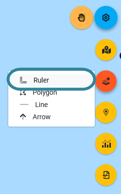
The map is now in the measure distance mode, and the
 icon turns from orange to white.
 -
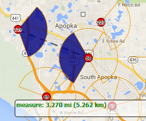
Left-click on the map to start measuring your distance. You can left-click to create another point on your distance measurement or double left-click to complete your distance measurement.
The distance is displayed in both miles and km at the bottom of the map.
Once you've completed your measurement right-click the map to return to the normal map mode which is indicated by the hand icon returning to orange
.